Orhun Aydin
Assistant Professor, Earth and Atmospheric Sciences, Saint Louis University
Assistant Professor (by courtesy), Computer Science , Saint Louis University

Des Peres Hall 202C
3672 West Pine Mall
St. Louis, MO 63108
I am an Assistant Professor in the Department of Earth and Atmospheric Sciences and the Department of Computer Science (by courtesy) at Saint Louis University, where I direct the AI-CHESS Lab (Artificial Intelligence in Coupled Human-Environment Systems for Sustainability and Resilience).
I am also the founding Director of ADAPT-STL, a U.S. Department of Energy-funded Resilience Center (one of only 10 nationwide) focused on building a hybrid urban digital twin of St. Louis, deploying a hybrid weather station network, and advancing community-driven resilience planning.
My research spans GeoAI, sensor networks, spatial statistics, and computational sustainability. I spatial machine learning and graph-based methods for geospatial analysis, design IoT sensor systems for urban environmental monitoring, and use UAVs and satellite imagery for environmental mapping. Application domains include urban heat islands, green/blue carbon, plastic pollution, methane mapping, food-water-energy security, and climate resilience.
My recent funding includes awards from the U.S. Department of Energy, the National Science Foundation, NVIDIA, the Taylor Geospatial Institute, the R Consortium, and the EPA.
Prior to joining SLU, I served as a senior researcher and product engineer for the Spatial Statistics team at Esri. I hold a Ph.D. and M.Sc. in Geostatistics from Stanford University, an M.Sc. in Computer Science from Georgia Institute of Technology, and dual B.Sc. degrees in Petroleum Engineering and Electrical & Electronic Engineering from Middle East Technical University. I am an FAA-licensed drone pilot.
news
| Feb 1, 2026 | New paper published in Geothermics: “Predictive analytics and statistical time series imputation of subsurface temperatures for a campus-scale geothermal exchange field” — collaborative work with J.M. Tinjum, D. Fratta, and colleagues. |
|---|---|
| Dec 15, 2025 | AI-CHESS Lab students present 6 papers at AGU Fall Meeting 2025 in New Orleans, covering urban heat islands, fallow field mapping, IoT waste sensors, urban tree mapping, and urban microclimate modeling. |
| Dec 1, 2025 | New paper published in Applied Computing and Geosciences: “Graph-based evidence accumulation for clustering 3D orientation measurements in planetary surface mapping under relational constraints.” |
| Nov 1, 2025 | AI-CHESS Lab co-authors 6 abstracts at ASN Kidney Week 2025, applying GeoAI methods to nephrology and kidney disease research in collaboration with the SLU School of Medicine. |
| Oct 1, 2025 | Rockwood School District students Adithya Chengalvala and Satvik Seetharaman, mentored by Dr. Aydin, are selected for the AGU Bright STaRS program to present their research at AGU 2025. Read more. |
latest posts
research highlights
2025
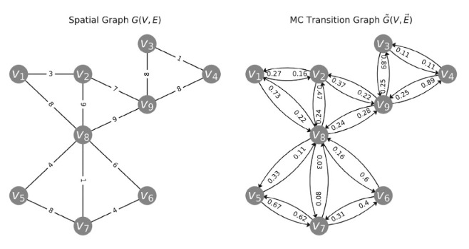
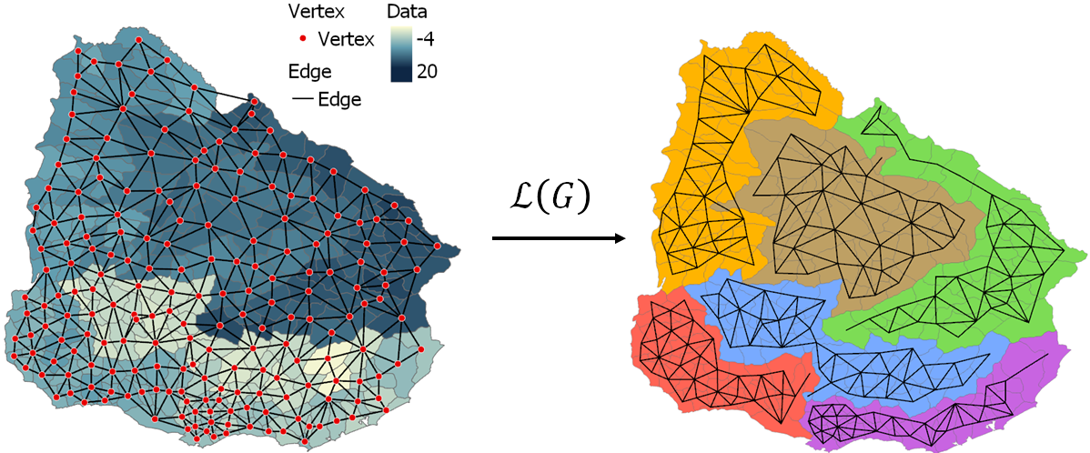
- ACAGGraph-based evidence accumulation for clustering 3D orientation measurements in planetary surface mapping under relational constraintsApplied Computing and Geosciences, 2025
2023
-
 Probabilistic Regionalization via Evidence Accumulation with Random Spanning Trees as Weak Spatial RepresentationsGeographical Analysis, 2023

2022
-
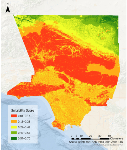
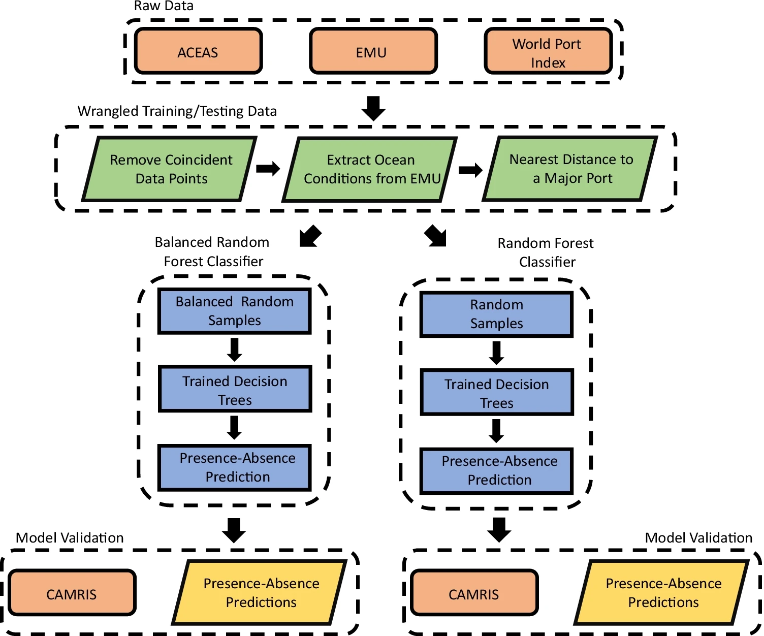 Conservation planning implications of modeling seagrass habitats with sparse absence data: a balanced random forest approachJournal of Coastal Conservation, 2022

2021
-
 Quantifying the Impact of a Tsunami on Data-Driven Earthquake Relief Zone Planning in Los Angeles County via Multivariate Spatial OptimizationGeosciences, 2021

2020
-
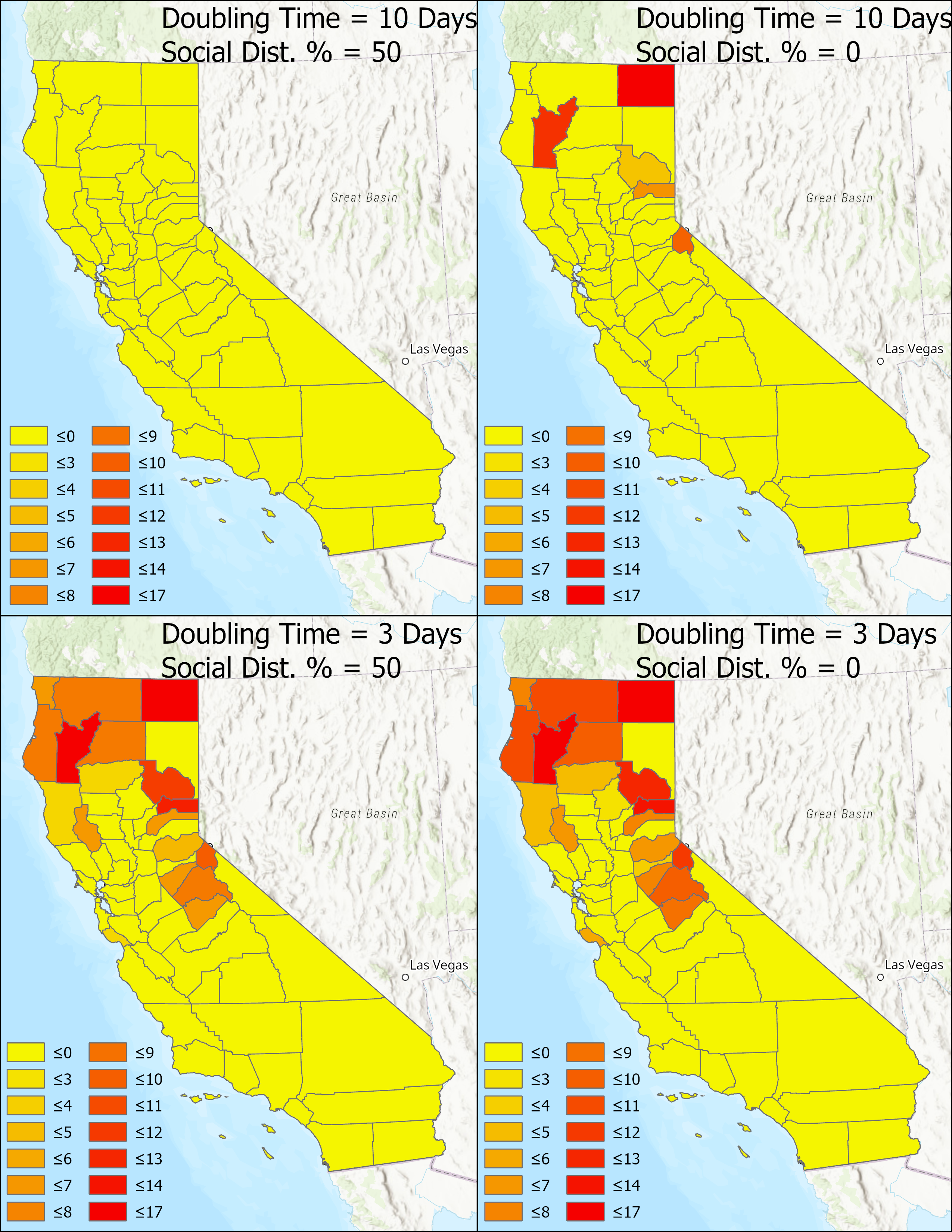 Sensitivity analysis for covid-19 epidemiological models within a geographic frameworkIn Proceedings of the 1st ACM SIGSPATIAL International Workshop on Modeling and Understanding the Spread of COVID-19, 2020

2018
-
 SKATER-CON: Unsupervised regionalization via stochastic tree partitioning within a consensus framework using random spanning treesIn Proceedings of the 2nd ACM SIGSPATIAL international workshop on AI for geographic knowledge discovery, 2018
